Photogrammetry Services in Houston
Photogrammetry is one of the most advanced and accurate methods for capturing real‑world environments and converting them into measurable digital models. At Home & Solar Services LLC, we provide professional photogrammetry services using high‑resolution aerial imaging, automated flight planning, and precision data processing. This technology allows us to generate detailed 2D orthomosaics, 3D models, elevation maps, and volumetric measurements for residential, commercial, and industrial applications.
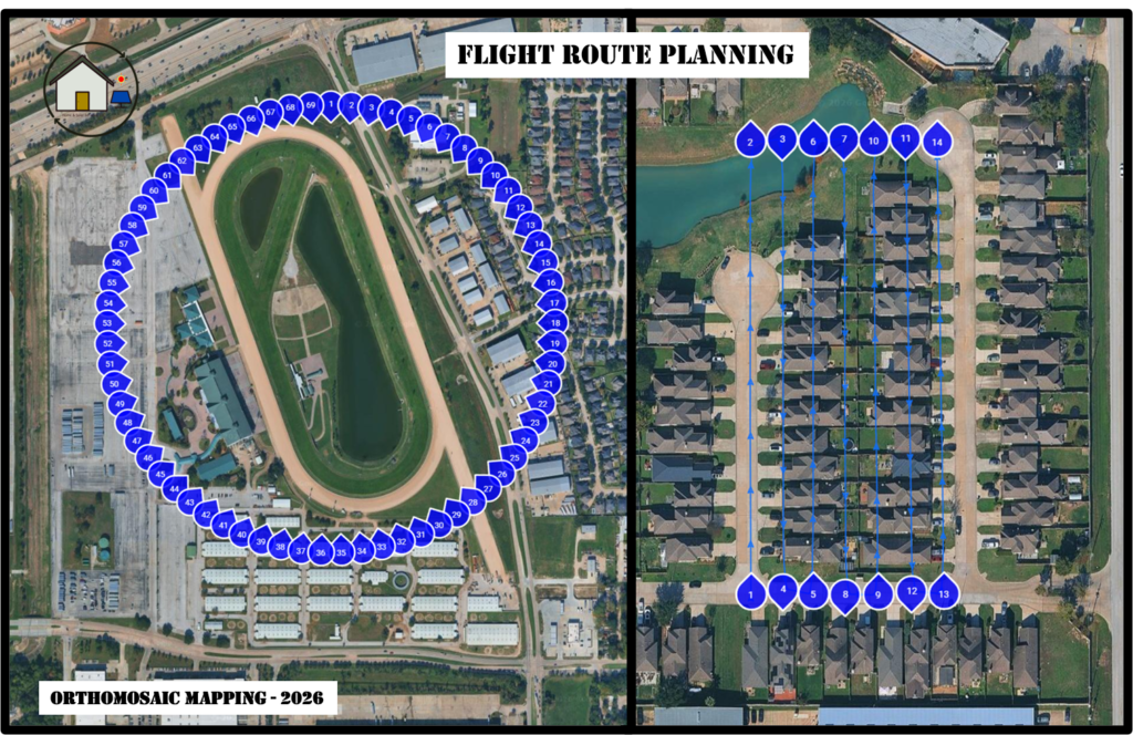
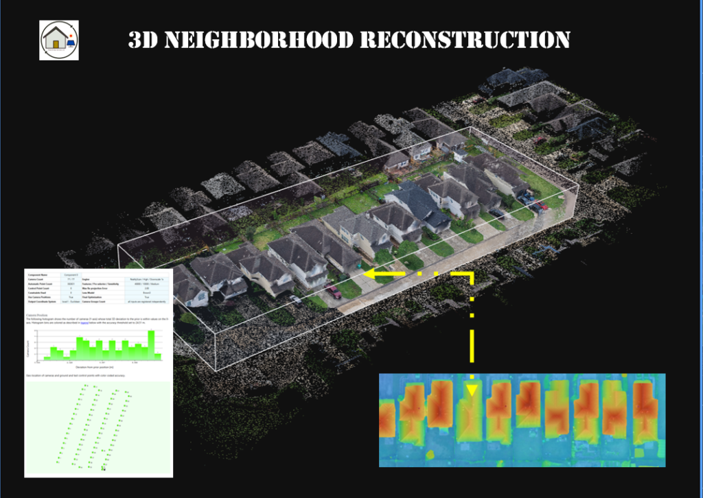
Our photogrammetry workflow combines automated drone flights with overlapping high‑resolution images, ensuring consistent coverage and precise reconstruction. This method is ideal for construction sites, land development, roof assessments, solar planning, property documentation, and any project that requires accurate spatial data. By capturing hundreds of images from multiple angles, we create digital models that reveal dimensions, surface conditions, structural details, and terrain variations with exceptional clarity.
Photogrammetry offers significant advantages over traditional measurement methods. It reduces time on site, eliminates the need for manual climbing or physical contact with structures, and provides a permanent digital record that can be reviewed, shared, or analyzed at any time. The resulting models are highly accurate and can be used for inspections, planning, engineering, insurance claims, and progress tracking.
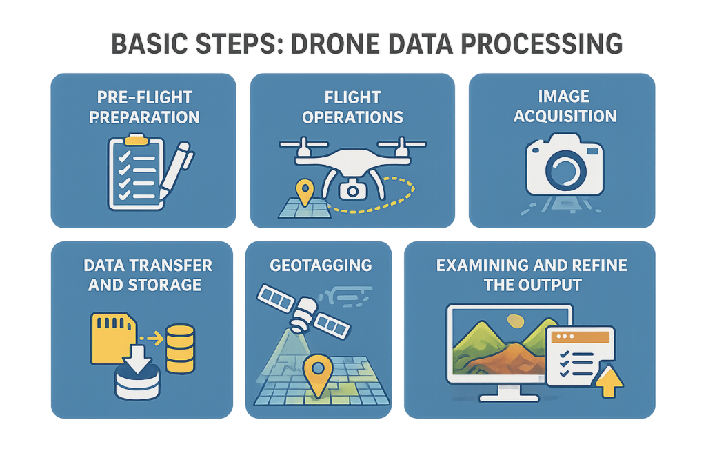
Our service includes automated flight planning, aerial image capture, data processing, and delivery of the final digital assets. Depending on your needs, we can provide orthomosaic maps, 3D textured models, point clouds, elevation profiles, contour lines, and volumetric calculations. All deliverables are provided in easy‑to‑use formats compatible with engineering, construction, and GIS platforms.
Photogrammetry is ideal for contractors, architects, engineers, surveyors, real estate professionals, insurance adjusters, and property owners who require precise visual and spatial information. Whether you need a detailed roof model, a site map, or a full 3D reconstruction, our photogrammetry services deliver accuracy, efficiency, and professional‑grade results across Houston, Cypress, Spring, Tomball, Katy, and surrounding areas.
Professional Photogrammetry
High‑Accuracy Mapping
Photogrammetry is a powerful technique that transforms high‑resolution aerial images into measurable, geo‑accurate digital products. Using automated flight paths and precision imaging, we generate detailed 2D maps, 3D models, orthomosaics, elevation data, and measurement‑ready outputs suitable for inspections, construction, real estate, land development, and documentation.
Our workflow is designed for clients who need reliable, repeatable, and professional‑grade results. Every project includes mission planning, automated flight execution, and structured image capture to ensure consistent coverage and high‑quality data.
What Photogrammetry Is Used For
Photogrammetry provides measurable, visual, and analytical information for a wide range of applications:
- Roof and property documentation for inspections, insurance claims, and condition assessments.
- Construction progress tracking with accurate before/after comparisons.
- Land development and planning, including acreage measurements and site modeling.
- Solar panel planning, shading analysis, and roof surface mapping.
- 3D modeling of structures, terrain, and architectural features.
- Orthomosaic mapping for large properties, farms, or commercial sites.
- Volume calculations for materials, stockpiles, and earthwork.
Photogrammetry delivers precise, measurable outputs without the need for physical access to hazardous or hard‑to‑reach areas.
Advantages of Our Service
Our imaging platform provides several key benefits that enhance accuracy, efficiency, and data quality:
- High‑resolution image capture for detailed mapping and modeling.
- Automated flight missions that ensure consistent overlap and coverage.
- Stable imaging performance that reduces distortion and improves reconstruction quality.
- Efficient data collection, allowing large areas to be captured quickly.
- Reliable results suitable for professional inspections, engineering documentation, and reporting.
These advantages translate into cleaner models, sharper orthomosaics, and more dependable measurements for your project.
Pricing Structure
Our pricing is transparent, simple, and designed to fit projects of all sizes.
Base Flight Fee – $285
Includes:
- Mission planning
- Automated flight execution
- Aerial image capture
- Coverage for areas up to 1 acre
Area‑Based Pricing
- Up to 1 acre: Included in the base fee
- More than 1 acre: $30 per additional acre
Travel Fee
- $1 per mile (round‑trip from Houston, TX 77064)
Image Processing
Pricing is based on the number of photos required for your project:
- Up to 800 photos: $300
- 801 to 1450 photos: $450
Processing includes:
- Orthomosaic generation
- 3D model reconstruction
- Digital surface data
- Measurement‑ready outputs (area, distance, volume when applicable)
Contact us to request a quote.